
In the past, flood protection was often strongly focused on technical measures. Sustainable flood prevention focuses more on natural flood protection, addresses the causes of floods, restricts the use of land along rivers and raises awareness of natural hazards among the population.
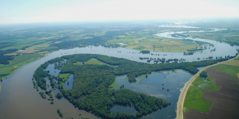
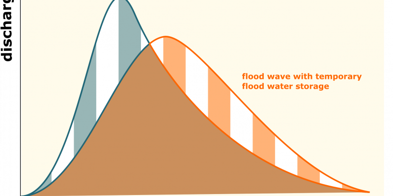
30.12.2022 459In the past centuries, dikes close to the river banks have cut off many floodplains from the rivers. As a result, the floodplains can no longer absorb and retain floodwaters. Today, only 20% of the natural floodplains remain on the major rivers Rhine, Elbe, Danube and Oder, as well as on the rivers Dosse, Ohre, Unstrut and Schwarzer Elster and on the alpine tributaries of the Danube (BfN 2021). These areas - also called flood retention areas - have an important function in the case of a flood: they buffer the course of a flood wave because they store and retain water temporarily (Figure 1).
An important requirement of the flood regulations of the Federal Water Act (WHG) is to make larger areas available for the overflowing of rivers. This can be achieved, by keeping floodplains free of certain uses (details on this can be found in the guidance documents of the federal states, such as the guidance documents on flood protection and flood management Construction planning law Brandenburg).
In this way, existing retention areas are preserved and new areas can be reclaimed. The designation of a floodplain is not arbitrary. It is based on the natural framework conditions, which are oriented to the extent of a 100-year flood.
Relocating dikes creates flood retention areas. It also makes it possible to naturalise watercourses by giving them more space for self-dynamic development and reconnecting floodplains to the river. By doing so, important ecosystem services of watercourses (e.g. habitat for many animal and plant species, biodiversity hotspots, nutrient filters, water reservoirs, carbon sinks) can be strengthened. Measures of natural flood protection are therefore well compatible with the objectives of watercourse and nature conservation and have many synergies. The online platform "Renaturation of Running Waters" provides information for potential initiators of renaturation projects. The ecological benefits of polders, which can be selectively flooded during floods, lag significantly behind the synergies of dike relocations.
 Principle change in a flood wave due to intermediate storage. If water is retained in the area because the river has room to spread out, the flood wave is less steep. However, the discharge rate remains constant (hatched areas are the same size). Figure according to the Bavarian State Office for the Environment." />
As a consequence of the major floods in May/June 2013 in the Danube and Elbe catchment areas, the a Special Conference of German Environment Ministers decided on 2 September 2013 to develop a nationwide, national flood protection programme (NFPP, in German NHWSP). The aim of the programme is to accelerate the implementation of priority and supra-regional preventive flood protection measures. The core of these measures is those that reduce flood levels on a nationwide scale: (1) Dike relocation / reclamation of natural retention areas, (2) Controlled flood retention through flood polders and flood retention basins, and (3) Elimination of vulnerabilities. The programme breaks new ground in flood risk management in Germany, as it understands the principle of solidarity by implementing preventive measures as a nationwide task. On an annual basis, the federal government finances these spatial measures (see list of measures) through the special framework plan "Preventive Flood Protection", which came into force in 2015, with up to € 100 million per year. As of 2021, flood polders with a retention volume of 825 million cubic metres and dike relocations with an area of 25,011 hectares were reported in the NFPP. If all measures are implemented (287 km², cf. NFPP area of reclaimed retention), the natural floodplain area (5,119 km², cf. BfN 2021 chap. 4, p. 16) increases by about 5 percent, based on the floodable area of all rivers in Germany with a catchment area larger than 1,000 square kilometres.
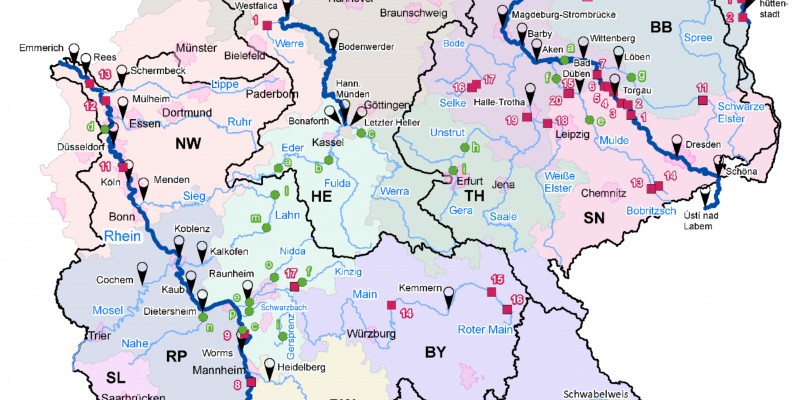
In an UBA research project carried out by the Federal Institute of Hydrology (BfG) (duration: 2016-2021), it was shown that all nationwide measures planned until 2020 (see Figure 2) in the river basins of the Danube, Elbe and Rhine make a significant contribution to lowering the peaks of floods. The reduction potential is between 10 and 50 centimetres for many of the modelled flood events. Both the overall impact of all measures and their individual influences show a strong nationwide effect. The recommendations derived from the results support the federal government and the federal states in the updating and further development of the content of the National Flood Protection Programme.
 as of 2020). The main gauges on the major rivers are also shown. Source: Federal Institute of Hydrology (BfG). " />
It is not enough to concentrate on the flood wave in the main stream during floods. In order to address the causes of flood development, water must already be retained at the headwaters and tributaries of larger rivers. On the one hand, this can be achieved through renaturation measures on streams and rivers and the protection and restoration of riparian forests, which delays the runoff of a flood wave. On the other hand, all measures that strengthen natural water retention in the landscape have a reducing effect on the occurrence of floods: more decentralised infiltration of rainwater and unsealing of surfaces in built-up areas, conservation tillage and creation of permanent vegetation cover in agriculture, adapted forest management and afforestation as well as rewetting of former wetlands and moors. The measures also address important goals of water, nature and climate protection as well as climate adaptation, as they reduce soil erosion, retain nutrients, promote biodiversity, store carbon and mitigate the effects of weather extremes (e.g. drought, heavy precipitation) on ecosystems. (Research project: Improvement of natural water retention in agricultural landscapes). In cities and metropolitan areas, decentralised infiltration and temporary storage of precipitation water in addition to protection against heavy rainfall are becoming increasingly important for reasons of climate adaptation. (Research project: Water-sensitive urban development). Further research projects are currently being carried out on the above-mentioned aspects.
The most effective way to prevent flood damage is not to build in floodplains. In defined floodplains, municipalities are not allowed to designate new building areas, so that an increase in damage potential is avoided. Only in exceptional cases the realisation of new constructions in floodplains is allowed, whereby clearly defined conditions apply (see § 78 paragraph 2 of the Federal Water Act) . Installation of new oil heating systems in flood plains are forbidden. Flood-proof modifications are obligatory for existing systems. Spilled heating oil can account for up to 70 % of the damage to buildings and cause major environmental damage to water bodies and soils. The federal states can make further specifications in legal regulations on permissible construction and other uses in floodplains. Also, the handling of substances hazardous to water can be specified by the federal states individually. Since 1 September 2021, the first nationwide spatial plan for flood protection has been in force, which aims to protect flood-prone areas more uniformly through forward-looking spatial planning.
Taking precautions in the event of a flood and keeping the damage caused by a flood as low as possible is not only the task of authorities, but also of every one of us. Self-preparedness starts with informing ourselves about the potential flood risk on site before a flood event (information preparedness): Do I live in a flood risk area or a designated floodplain? Are there current flood warnings and forecasts about the expected water level of flood-bearing rivers? What precautionary measures do the affected municipality and the water authorities of the federal states propose? An overview of existing information and warning portals can be found here.
Another aspect of self-preparedness concerns all structural measures that better adapt houses and flats to a risk of flooding - so-called building precautions: It includes both simple precautions such as the elevation of valuable objects as well as constructive adjustments of, for example, foundations, walls, house connections as well as doors and windows. In addition, insurance solutions create a further incentive for those affected to prepare for a flood (risk prevention) and reduce the costs for the general public. In this context, it is important to know that conventional household or residential building insurance policies do not compensate for damage caused by floods. Private households and businesses must therefore additionally and voluntarily obtain natural hazard insurance. The flood check of the German Insurance Association (GDV) can be used to check whether there is an increased risk of river floods for properties. In Germany, only 46 % of buildings were comprehensively insured against natural hazards in 2021 (GDV 2021).
Technical flood protection, especially dyke construction, is an integral part of comprehensive flood prevention. Dykes and flood protection walls have been used for centuries to protect houses, industry and transport infrastructure from floods. Technical flood protection measures should not give the illusion of one hundred percent safety and should not lead to further construction in flood risk areas. Dykes and dams protect against floods - but only up to a certain water level and a certain duration of the flood. There is no absolute flood protection. If a dyke breaks or other flood protection facilities fail, the damage is usually very severe. The construction of dykes and embankments also leads to an acceleration of the runoff. This increases the risk of flooding for downstream communities (downstream riparians). In addition, dykes separate rivers from their natural floodplains, which has far-reaching negative consequences for the ecological functioning of flowing waters and their floodplains and for the landscape water balance.